MasterPlan: Water
- Home
- MasterPlan
Pipe Deficiency Assessment INASAT
INASAT Masterplan adds actionable data and insights to your asset management plan in one easy data layer. Our patented system uses a newly developed algorithm that’s been trained on five years of system leaks discovered by INASAT Recover, our leak detection and analysis product.
Product Overview
The algorithm assesses pipe deficiencies using multiple synthetic aperture radar (SAR) images and can observe an entire pipe system, even for large cities, using multiple satellite passes.
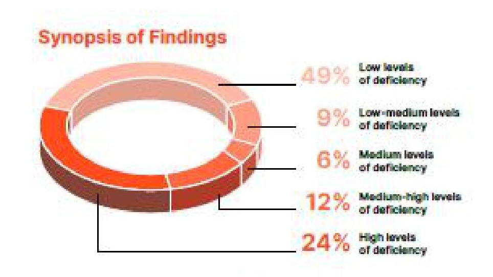
The trained algorithm then scores pipe segments exhibiting non-surfacing leaks detected in one or more images; it also analyzes leak location clusters within them. Data points are then scientifically combined into a single GIS data output with pipes scored on a 1-5 scale: 1 indicates low levels of deficiency observed; 5 denotes high levels of deficiency. The data inputs easily to any GIS system or asset planning model.
Utilities and engineers use MasterPlan to gain insight into the pipes’ actual condition. The system is compatible with all GIS and GIS-based asset planning model software and integrates with attribute data such as pipe age, material, and work orders from surfacing leaks. MasterPlan adds a valuable level of refinement to pipe replacement planning models or water system master plans.
How INASAT MasterPlan works
Satellite images are acquired
Soil moisture is identified
MasterPlan's algorithm analyzes the data
We deliver GIS data to the customer
The MasterPlan Differentiators
MasterPlan provides unique insights that are not available elsewhere, such as an actual measurement of non-surfacing pipe leaks - not a predictive analysis. The system is completely non-invasive as data is collected via satellite, and the pipes' size and composition do not matter. The 3,500- sq km coverage area observes and analyzes the most expansive systems with unmatched speed and efficiency.

Why Choose MasterPlan?
- A full system-wide view to set replacement priorities
- Efficient deployment of fixed acoustic assets
- Easy input to a replacement planning model or water system master plan
- Non-invasive assessment means no cost or disruptions from crews digging
- Completely pipe-agnostic, working on pipes of any size or material
- Easily integrates with all GIS and asset management tools such as those from partners Esri and Innovyze
What's Included?
- GIS dataset with deficiency levels
assigned by Pipe ID - Summary report
- Free online viewer
- INASAT customer support
MasterPlan is available as a stand-alone
service or as an add-on to INASAT
About INASAT
Utilis developed the INASAT products to use satellite-based synthetic aperture radar (SAR) to locate and analyze moisture accumulating underground. Our products include MasterPlan for pipe deficiency assessment; Recover for leak detection; and EarthWorks for ground infrastructure assessment. INASAT pierces clouds, forests, and even pavement to assess entire systems quickly and efficiently. Our first commercial use was in 2016. Since then, 36,000 leaks have been verified, saving 35 million m3 of drinkable water and 21,800 MWH of energy every year, savings that continually grow.
Join Us in Shaping the Future of Leading-Edge Solutions
You can now identify your water loss and reduce non-revenue water cost-effectively and without the need to shut down your pipeline.